Turn Your historical Soil Samples into VR Fertilization maps for Liming
- sandorfehervari

- Apr 1, 2025
- 2 min read
Updated: Apr 2, 2025
mYields is proud to introduce its latest offering that supports farmers in making Field Zone specific fertilization decisions. At the heart of this service is a model that smooths and interpolates soil sample point data to create accurate and actionable layers for each soil nutrient. Designed specifically for autumn fertilisation, the system generates detailed maps for Phosphorus (P) and Potassium (K) recommendations, which is now extended to Spring Lime applications.

How It Works
The model begins with the collection of available soil sample points of the fields. Using smoothing algorithms, this data is interpolated to build continuous, high-resolution layers. These layers represent the spatial distribution of key nutrients for the autumn fertilization planning. By analyzing the distribution of P and K in the field, the system considers the nutrition availability the crop need and the farmer defined yield target to caclculate the targeted application rates. This spring, the autumn model is expended to Ca data specifically for sunflower production, where lime content plays a vital role in root development and nutrient uptake.
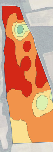
Ca Nutrition Plans for Sunflower fields based on available soil samples


The process reviews nutrition needs and considers Farmer budgets. We can limit the models to the Farmer Field budget to ensure they don't apply more then they planed, while it will generate saving if the advice is lower then the farmer budget.
The model adjust based on the Farm machinery needs, so based on it's age and quality we can decrease or increase the number of zones the the rate differences, so we can create Ca maps to change at every 20kg or 40kg of Mass Fertiliser which will decrease the Zones complexity.
When we started our PrecisionAg division we wanted to create technological solutions working in standard farm practice. We've seen so many pixels and Satellite based solutions even today which don't consider natural breaks, and machinery capacity. We are proude to share our smoothing process which turns science into applicable maps.


Comments